Introduction: Navigating the World of Geospatial Queries
In the realm of data, location information adds a whole new layer of insights. Welcome to the universe of geospatial queries with PostGIS — the PostgreSQL extension designed to handle spatial data seamlessly. This voyage takes you through the art of querying and analyzing spatial information, from pinpointing nearby points to unraveling complex spatial patterns.
Section 1: The Foundation of Spatial Data in PostGIS
Before diving into queries, let’s understand how spatial data is stored in PostGIS. Points, lines, and polygons are represented using geometries, which contain coordinates. Imagine creating a simple table to store points representing cities:

Section 2: Finding Nearby Points with Proximity Queries
One of the most common spatial queries is finding nearby points within a certain radius. PostGIS makes this task a breeze. Imagine finding cities within 500 kilometers of a given location:

Section 3: Exploring Spatial Relationships
Spatial relationships play a crucial role in geospatial queries. PostGIS offers functions to check relationships like intersection, containment, and adjacency. Imagine finding cities that intersect with a given polygon:

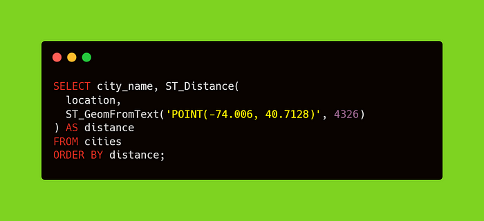
Section 4: Calculating Distances and Area
PostGIS provides functions to calculate distances between points and areas of polygons. Imagine calculating the distance between two cities:
Section 5: Visualizing Spatial Data with Visualization Tools
Visualization is key to understanding spatial data. PostGIS integrates well with various visualization tools like QGIS and GeoServer. Imagine creating a simple map of cities using QGIS:

Section 6: Aggregating Spatial Data
Aggregating spatial data allows you to summarize information within specific regions. Imagine calculating the total population within a polygon:

Section 7: Handling Geospatial Complexities with Topology
Topology is the study of spatial relationships between objects. PostGIS offers topology support for handling complex spatial relationships. Imagine ensuring that no two polygons in a layer overlap:

Section 8: Analyzing Movement and Patterns
Geospatial queries extend beyond static data; they can analyze movement and patterns. Imagine analyzing the movement of vehicles over time:

Section 9: Leveraging Geospatial Insights
The world is rich with spatial data, waiting to be explored. As you master geospatial queries with PostGIS, you unlock the ability to make informed decisions based on location insights. From business optimization to urban planning, the power of spatial queries reshapes how you interact with the world of data.